
LT800H
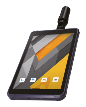
The LT800H RTK tablet is a high-accuracy GNSS receiver designed for professional geospatial users. It offers real-time kinematic (RTK) positioning for precision surveying, mapping, and GIS data collection.
The LT800H features a rugged design built to withstand harsh environments, ensuring reliable and accurate data collection.
PERFECT FOR:
forensic mapping
agricultural irrigation design
environmental surveys
landscaping
farm management
landscaping
positioning on earthmoving jobs.
ACCURACY AT YOUR FINGERTIPS
Hight performance GNSS RTK networks corrections
Equipped with a 1408-channel GPS, GLONASS, Galileo, and BeiDou module.
Superior tracking GNSS helix antenna delivers best-in-class centimeter-to-decimeter positioning accuracy, even in challenging environments
ROBUST AND RUGGED DESIGN
Industrial IP67 design for durability against dust, water, drops, and shocks.
8.1″ Corning Gorilla Glass 3 IPS touchscreen, sunlight-viewable for clear visibility outdoors.
Designed to operate seamlessly in adverse weather conditions.
CONNECTIVITY AND EFFICIENCY
Connectivity and Efficiency
Integrated 4G modem ensures seamless connectivity to GNSS RTK network corrections. High-performance processor for displaying large maps and data sets without lag. Capacitive multi-touch screen compatible with stylus, gloves, or wet hands.
LONG BATTERY LIFE
9000mAh Li-ion battery provides up to 8 hours of continuous operation.
Minimizes downtime and maximizes productivity in the field.
The LT800H RTK tablet is ideal for various applications, including GIS data collection, surveying and mapping, construction site layout, environmental studies, and landscaping. Its rugged design and high performance ensure that data collection is accurate and efficient, making it a valuable tool for geospatial professionals.
SPECIFICATIONS:
Specification: LT800H (PDF)
Contact Details
086 111 2783
021 975 7043
Quick Links
Home
Shop Online
Get a Quote
Software
Equipment
Training
Privacy Policy
Contact Us
Social Media
© 2025 MMS Design | All Rights Reserved | Web SEO by: DNASuperSystems