
GPSNET
Unlock centimetre-level accuracy with GPSNet’s high-performance Continuously Operating Reference Station (CORS) network.
Powered by full-constellation GNSS—GPS, GLONASS, Galileo, and BeiDou—our real-time satellite corrections deliver rock-solid positioning for surveying, mapping, construction, agriculture, and any geospatial project that demands absolute precision.
Subscription plans :
Month-to-Month:
Ideal for short-term projects or users who require flexibility. Enjoy full access to GPSNet’s high-accuracy corrections without a long-term commitment.
CHCNAV equipment users R570
All other users R805
6-Month Subscription:
Perfect for medium-term requirements, offering a balance between commitment and cost savings. Get uninterrupted service and consistent data 6 months.
CHCNAV equipment users R3100
All other users R4340
12-Month Subscription:
Best suited for ongoing projects and regular users who want the most cost-effective option. This plan provides continuous access for a full year.
CHCNAV equipment users R5750
All other users R8050
No matter which plan you choose, GPSNet works effortlessly with a wide range of GNSS devices and receivers—helping you achieve maximum productivity and pinpoint accuracy in every field operation. Stay connected, stay precise, and work smarter with GPSNet.
Looking for dependable NTRIP correction services in your area? Get in touch with us today.
ORDER STATIC RINEX DATA
GPSNet Record 5s Rinex static data for up to 7 days in the past including today. You can place a order for Rinex data by completing our order form and sending it to us.

GPSNet — Where Every Fix Counts.
Unmatched Accuracy. Uncompromising Reliability.
Powered by CHCNAV.
At GPSNet, we’ve built a privately owned, dual-cloud GNSS correction network to deliver RTK corrections to your rover, reliability and accurately with up to 2cm accuracy anywhere inside our CORS network or within 20km of any of our CORS stations. We invested in 2 independent cloud servers providing our customers double redundancy ensuring 99% uptime— so you stay connected when it matters most.

Superior Performance in Every Environment
Our network is optimised for challenging environments, delivering higher fix rates thanks to full-constellation support across GPS, GLONASS, Galileo, BeiDou, and SBAS. More satellites mean faster initialisation, greater accuracy, and consistent performance—even in urban canyons, dense vegetation, or remote worksites. And with our coverage expanding every month, your service area grows with us.
Precision Hardware for Precision Results
Every GPSNet CORS station is powered by CHCNAV’s industry-leading GNSS technology, trusted worldwide for its accuracy and reliability. Leveraging the CHCNAV Precision Positioning Service (CPS), our modular software framework integrates real-time data streaming, advanced computation, and intelligent user management for scalable, multi-brand compatibility.

Built for the Harshest Conditions
Our flagship CHCNAV P5 GNSS reference stations feature:
IP67-rated enclosures for all-weather durability
Redundant network options for continuous uptime
(Ethernet, 4G, Wi-Fi)
Smart data management for optimal RTK corrections
Proven reliability with MTBF over 35,000 hours
Why Choose GPSNet?
Because every detail of our network—hardware, software, and infrastructure—is engineered for one thing: delivering centimetre-level accuracy with unmatched dependability.
GPSNet. Reaching Further. Fixing Faster. Working Smarter.
Who Can Use GPSNet:
Surveyors:
Professional land surveyors who require high-precision GNSS corrections for tasks like boundary surveys, topographic surveys, and construction layout.
Engineers:
Civil, geotechnical, and structural engineers who need accurate GNSS data for planning, design, and construction projects.
GIS Professionals:
Geographic Information System (GIS) specialists and cartographers who rely on precise geospatial data for mapping and analysis.
Construction Managers:
Project managers and operators using GNSS-guided machinery for tasks such as grading, excavation, and site layout.
Agriculture Professionals:
Farmers and agricultural service providers using GNSS-guided systems for precision farming, crop management, and field mapping.
Geospatial Analysts:
Experts in environmental studies, disaster management, and urban planning who need reliable GNSS data for spatial analysis.
Researchers and Academics:
Researchers conducting studies that require precise geolocation data, such as environmental monitoring, archaeology, and earth sciences.
Reaching Further Together
As GPSNet gains more subscribers, we’re committed to expanding coverage and boosting reliability—helping you achieve more, in more places, with complete confidence.
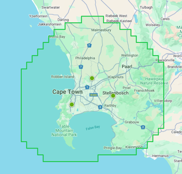
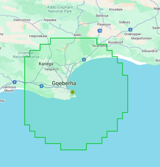
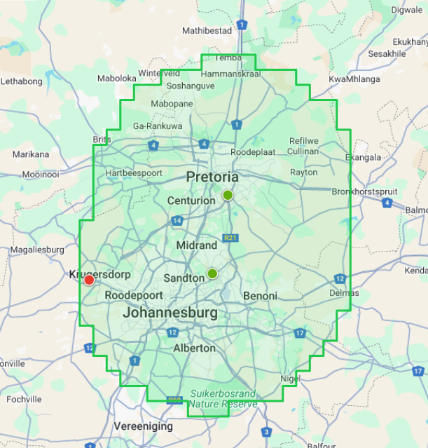
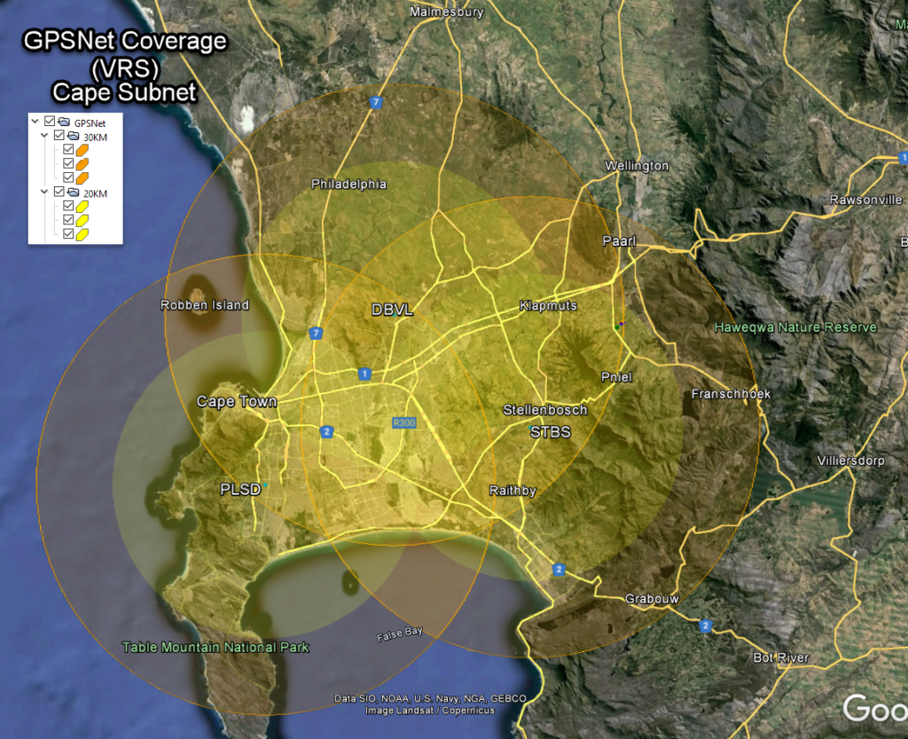
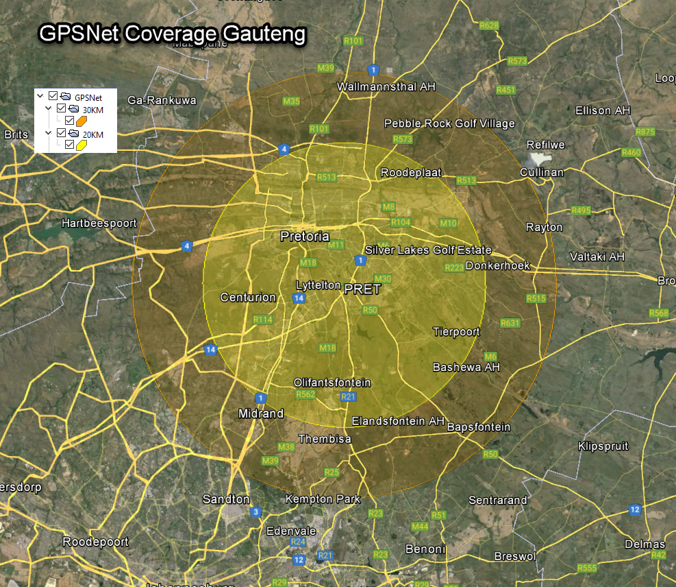
Coverage Areas as at August 2025
Watch this space as we expand and grow our network.
TX73 GNSS Guidance
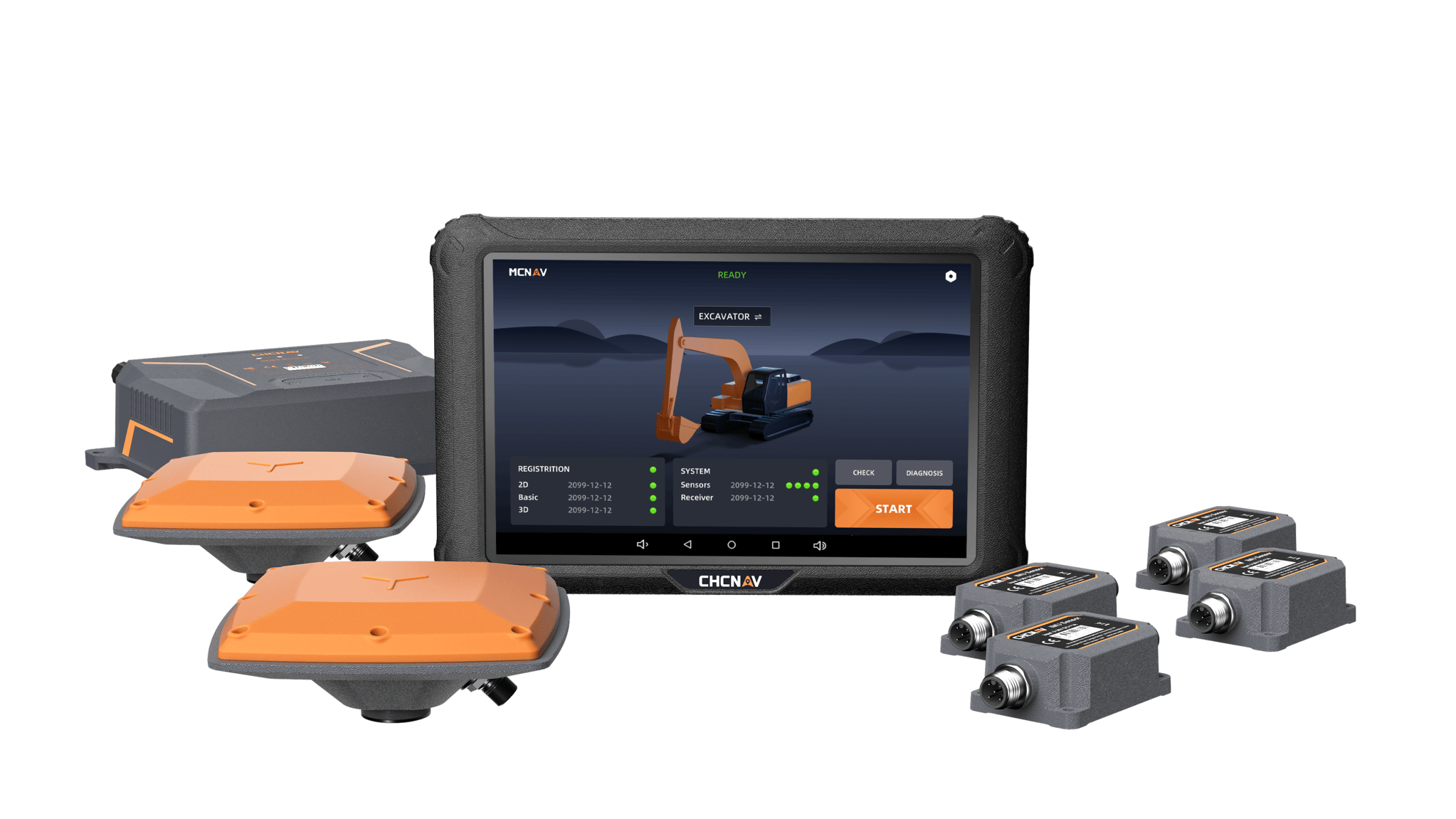
Premium RTK GNSS Excavator Guidance
Social Media
© 2025 MMS Design | All Rights Reserved | Web SEO by: DNASuperSystems
Coverage Areas as at September 2024
Watch this space as we expand and grow our network.
Wide-coverage dual-camera LiDAR for demanding UAV surveys
Up to 2,100 m range
Up to 2,000 kHz pulse rate
Up to 16 returns
1.85 kg integrated system
CHCNAV AlphaAir 6 Dual (AA6D)
Capture LiDAR and high-quality imagery across wide corridors and large-area projects with dual 26 MP APS-C cameras and a 110° horizontal field of view.