
Agisoft Professional Photogrammetry Software
Metashape – photogrammetric processing of digital images and 3D spatial data generation
Agisoft Metashape is a stand-alone software product that performs photogrammetric processing of digital images and generates 3D spatial data to be used in GIS applications, cultural heritage documentation, and visual effects production as well as for indirect measurements of objects of various scales.
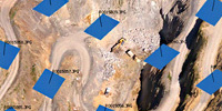
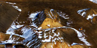
Photogrammetric triangulation
Processing of various types of imagery: aerial (nadir, oblique) & close-range.
Auto calibration: frame (incl. fisheye), spherical & cylindrical cameras.
Multi camera projects support.
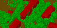
Dense point cloud: editing and classification
Elaborate model editing for accurate results.
Points classification to customize geometry reconstruction.
.LAS export to benefit from classical point data processing workflow.
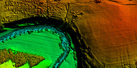
Digital elevation model: DSM/DTM export
Digital Surface and/or Digital Terrain Model — depending on the project.
Georeferncing based on EXIF meta data/flight log: GPS/GCPs data.
EPSG registry coordinate systems support: WGS84, UTM, etc.
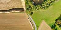
Georeferenced orthomosaic export
Georeferenced orthomosaic: most-GIS-compatible GeoTIFF format; .KML file to be located on Google Earth.
Export in blocks for huge projects.
Color correction for homogeneous texture.
Measurements: distances, areas, volumes
Inbuilt tools to measure distances, areas and volumes.
To perform more sophisticated metric analysis Metashape products can be smoothly transferred to external tools thanks to a variety of export formats.
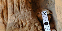
Ground control points: high accuracy surveying
GCPs import to control accuracy of the results.
Coded/non-coded targets auto detection for fast GCPs input.
Scale bar tool to set reference distance without implementation of positioning equipment.
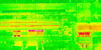
Multispectral imagery processing
RGB/NIR/thermal/multispectral imagery processing.
Fast reconstruction based on preferable channel.
Multichannel orthomosaic generation for built-in vegetation indices (NDVI) calculation and export.
3D model: generation and texturing
Various scenes: archaeological sites, artifacts, buildings, interiors, people, etc.
Direct upload Sketchfab resource and export to varios popular formats.
Photorealistic textures: HDR and multifile support.
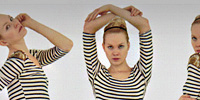

4D modeling for dynamic scenes
Multi camera station data processing for creative projects in cinemato- graphic art, game industry, etc.
Basis for numerous visual effects with 3D models reconstructed in time sequence.
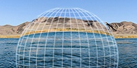
Panorama stitching
3D reconstruction for data captured from the same camera position — camera station, provided that at least 2 camera stations are present.
360° panorama stitching for one camera station data.
Bottom CTA
Network processing
Distributed calculations over a computer network to use combined power of multiple nodes for huge data sets processing in one project..
Agisoft Professional Photogrammetry Software
Metashape – photogrammetric processing of digital images and 3D spatial data generation
Agisoft Metashape is a stand-alone software product that performs photogrammetric processing of digital images and generates 3D spatial data to be used in GIS applications, cultural heritage documentation, and visual effects production as well as for indirect measurements of objects of various scales.
Photogrammetric triangulation
Processing of various types of imagery: aerial (nadir, oblique) & close-range.
Auto calibration: frame (incl. fisheye), spherical & cylindrical cameras.
Multi camera projects support.
Dense point cloud: editing and classification
Elaborate model editing for accurate results.
Points classification to customize geometry reconstruction.
.LAS export to benefit from classical point data processing workflow.
Digital elevation model: DSM/DTM export
Digital Surface and/or Digital Terrain Model — depending on the project.
Georeferncing based on EXIF meta data/flight log: GPS/GCPs data.
EPSG registry coordinate systems support: WGS84, UTM, etc.
Georeferenced orthomosaic export
Georeferenced orthomosaic: most-GIS-compatible GeoTIFF format; .KML file to be located on Google Earth.
Export in blocks for huge projects.
Color correction for homogeneous texture.
Measurements: distances, areas, volumes
Inbuilt tools to measure distances, areas and volumes.
To perform more sophisticated metric analysis Metashape products can be smoothly transferred to external tools thanks to a variety of export formats.
Ground control points: high accuracy surveying
GCPs import to control accuracy of the results.
Coded/non-coded targets auto detection for fast GCPs input.
Scale bar tool to set reference distance without implementation of positioning equipment.
Multispectral imagery processing
RGB/NIR/thermal/multispectral imagery processing.
Fast reconstruction based on preferable channel.
Multichannel orthomosaic generation for built-in vegetation indices (NDVI) calculation and export.
3D model: generation and texturing
Various scenes: archaeological sites, artifacts, buildings, interiors, people, etc.
Direct upload Sketchfab resource and export to varios popular formats.
Photorealistic textures: HDR and multifile support.
4D modeling for dynamic scenes
Multi camera station data processing for creative projects in cinemato- graphic art, game industry, etc.
Basis for numerous visual effects with 3D models reconstructed in time sequence.
Panorama stitching
3D reconstruction for data captured from the same camera position — camera station, provided that at least 2 camera stations are present.
360° panorama stitching for one camera station data.
Bottom CTA
Network processing
Distributed calculations over a computer network to use combined power of multiple nodes for huge data sets processing in one project..
Constant Updates & World-class Support Services
All of our Software and Survey Equipment are covered by world-class support.
We provide unmatched user support and training on everything we sell.
Contact Details
086 111 2783
021 975 7043
Quick Links
Home
Shop Online
Get a Quote
Software
Equipment
Training
Privacy Policy
Contact Us
Social Media
© 2025 MMS Design | All Rights Reserved | Web SEO by: DNASuperSystems